Wednesday, April 11, 2012

Mount Everest


Mount Everest

The official altitude of the world's highest peak Mount Everest is 29,029 feet (8,848m). However, the National Geographic Society has determined the height to be 6 feet taller, 29,035 feet, but the Nepali government has not yet been made this new altitude official.

Shifting tectonic plates continue to push Mount Everest upward, along with the whole Himalaya mountain range, at 1.6 to 3.9 inches (4 to 10 centimeters) per year.


Mount Everest

Mount Everest is part of the Himalaya mountain range along the border of Nepal and Tibet. It is located 27° 59' North latitude, 86° 55' East longitude.
In 1841, Sir George Everest, Surveyor General of India from 1830 to 1843, first recorded the location of Everest. It was subsequently named "Peak XV". In 1865, it was renamed Mt. Everest to honor Sir George.

Everest is also called Chomolungma in Tibet and Sagarmatha in Nepal.


Mount Everest

Yes. Blowing with the strength of a hurricane at 118+ miles/hour, the Jet Stream blasts the rocky, icy summit of Mount Everest nearly all year long. The Jet Stream is a constant wind force at 4 - 6 miles above the earth. Observers can tell when the Jet Stream is blowing on the summit of Mount Everest from the long while stream of ice crystals extending out from the tip of the mountain. Those wishing to actually stand on the summit have to choose their moment carefully: the mountain is most inviting in early May, when the Jet Stream is pushed northward over Tibet by the arrival of the monsoon. There is also a window of opportunity in the Fall when the Jet Stream is again pushed northward.


As the altitude increases, the oxygen content of the air decreases dramatically. At 9,800 feet, for example, there's about 2/3 of the oxygen in the air than at sea level. At 20,000 ft, there is roughly half the oxygen content in the air. At 29,035ft, the summit of Mount Everest, there is only a third of the oxygen in the air.


Mountaineers climbing Mount Everest establish a camp at the base of the mountain, and four higher camps before reaching the summit. For the next 30 days or so, they will move up, then down again, allowing their bodies to get used to the reduced oxygen content of the air. This process is called acclimatization.

Acclimatizing properly is essential to safely ascend to high altitudes. Climbers acclimatize by ascending slowly, resting one day for every 1,000 feet they climb in one day. They drink plenty of liquids and eat healthy food. They also practice a rule of thumb: climb high, sleep low. Climbing high, then descending to lower altitudes allows the body to build up and gain strength with fresh oxygen, digest food better, get sounder sleep and any wounds can heal and they'll feel much stronger by descending. It was also allow them to build up their bodies, worn from the low O2 content, with fresh oxygen.

Some climbers don't like to go down, but the significant benefits on the body from staying at lower altitudes make it worth it. It's important that the climbers don't stay down too long because it's possible to lose some acclimatization in the process.
At the summit, the temperature can be 100°F below zero. But on a good summit day, a climber can expect around -15°F


Each climber has a different opinion about what is the most difficult part of climbing Mount Everest. Most would agree, though, that the altitude is tough to deal with. And most will also have stories about crossing the infamous Khumbu Icefall going from Base Camp to Camp One. Mountaineers climb through this moving sea of ice using ordinary aluminum garden ladders.
On May 29, 1953, Tenzing Norgay Sherpa of Nepal & Edmund Percival Hillary of New Zealand climbed to the summit of Everest via the Southeast Ridge Route


The first woman to climb Everest was Junko Tabei of Japan. She climbed via the Southeast Ridge on 16 May, 1975.

Appa Sherpa has made the most successful ascents of Everest. He has reached the top 11 times.
On May 8, 1978, Peter Habeler of Austria and Reinhold Messner of Italy climbed made the first ascent without bottled oxygen via the Southeast Ridge.

Ang Rita Sherpa has reached the summit 10 times, all without oxygen.
Reinhold Messner climbed for 3 days completely alone from his base camp at 6,500m without the use of artificial O2. Messner climbed via the North Col to the North Face and the Great Couloir.

Babu Chiri Sherpa set the speed record from the Nepal side.

Davo Karnicar made the first true ski descent.

At age 16 Temba Tsheri Sherpa become the youngest person to Summit Everest in 2001.

American Sherman Bull, at age 64, is the oldest person to summit Mount Everest, also in 2001.

Anna Czerwinska was born on 7/10/49 and climbed Everest from Nepal side, making her the oldest woman to reach the summit.
On 24 May, 1996, Hans Kammerlander of Italy Hans made the fastest ascent of Everest via the standard North Col-North Ridge-North Face. He left base camp at 6,400m on 23 May at 5pm and was on the summit 16 hours, 45 minutes later at 9:45 am the next day. He descended most of the route on skis.

Andrej & Marija Stremfelj of Slovenia were the first married couple to summit together on 7 October, 1990.

Peter Hillary of New Zealand was the first son of a summiteer to reach the summit on 10 May, 1990.

First Ascent by an American was made by James Whittaker via the Southeast Ridge Route on May 1, 1963. Whittaker summitted with Sherpa Nawang Gombu.

Stacey Allison made the first Ascent by an American Woman via the Southeast Ridge Route on 29 September, 1988.

Mexican climber Ricardo Torres was the first Latin American.

In May, 2001, American Erik Weihenmayer becomes the first blind person to summit Everest.


Courtesy BY:  http://www.teameverest03.org/everest_info/index.html

Tuesday, April 10, 2012

Great Wall Of China


Great Wall of China


The Great Wall of China is not a continuous wall but is a collection of short walls that often follow the crest of hills on the southern edge of the Mongolian plain. The Great Wall of China, known as "long Wall of 10,000 Li" in China, extends about 8,850 kilometers (5,500 miles).


A first set of walls, designed to keep Mongol nomads out of China, were built of earth and stones in wood frames during the Qin Dynasty (221-206 BCE).


Some additions and modifications were made to these simple walls over the next millennium but the major construction of the "modern" walls began in the Ming Dynasty (1388-1644 CE).


Great Wall of China


The Ming fortifications were established in new areas from the Qin walls. They were up to 25 feet (7.6 meters) high, 15 to 30 feet (4.6 to 9.1 meters) wide at the base, and from 9 to 12 feet (2.7 to 3.7 meters) wide at the top (wide enough for marching troops or wagons). At regular intervals, guard stations and watch towers were established.


Since the Great Wall of China was discontinuous, Mongol invaders had no trouble breaching the wall by going around it, so the wall proved unsuccessful and was eventually abandoned. Additionally, a policy of mollification during the subsequent Ch'ing Dynasty that sought to pacify the Mongol leaders through religious conversion also helped to limit the need for the wall.


Great Wall of China


Through Western contact with China from the 17th through 20th centuries, the legend of the Great Wall of China grew along with tourism to the wall. Restoration and rebuilding took place in the 20th century and in 1987 the Great Wall of China was made a World Heritage Site. Today, a portion of the Great Wall of China about 50 miles (80 km) from Beijing receives thousands of tourists each day.

Traditionally known to the Chinese as the "Long Wall of Ten Thousand Li", the stretch of formidable defensive structures built to ward off invasion of the Celestial Empire by barbarians is most often called the "Great Wall" or the "Wall of China" by Europeans.


History of the Great Wall of China

The history of these extraordinary fortifications goes back to the Chunqiu period (722-481 B.C.) and to the Warring States period (453-221 B.C.), so-called because of the long struggle among seven rival dynasties for supreme power. The construction of certain walls can be explained by these feudal conflicts, such as the one built by the Wei in 408 B.C. to defend their kingdom against the Qin. Its vestiges, conserved in the center of China, precede by many years the walls that the Kingdoms of Qin, Zhao and Yan erected against the northern barbarians around 300 B.C.


The Great Wall of China at Simatai

Beginning in 220 B.C., Qin Shi Huang, the founder of the Empire of the Ten Thousand Generations, undertook to restore and link up the separate sections of Great Wall of China which had been built in the 3rd century B.C., or perhaps even earlier, and which stretched from the region of the Ordos to Manchuria. Towards the west, he had the fortifications extended in the valley of the Huanghe all the way to Lanzhou. Thus was the first cohesive defense system of which significant vestiges still remain, completed, shortly before the accession of the Han dynasty (206 B.C.). During their reign the Great Wall was extended even further, and under the emperor Wudi (140-87 B.C.) it spanned approximately 3700 miles (6,000 kilometers) between Dunhuang in the west to Bohai Sea in the east. The danger of incursion along northern Chinese border by the federated tribes of Mongols, Turks and Tunguz of the Empire of the Xiongnu, the first empire of the steppes, made a defense policy more necessary than ever. Alternating military actions with intensive diplomatic efforts, this policy entailed massive relocation of Chinese peoples within the frontier zone. In 102 B.C., there were 180,000 peasant soldiers in the "command posts" of Gansu.


The Last Door Under Heaven, Great Wall at Jiayuguan the far Northwestern End

After the downfall of the Han dynasty (220 A.D.), the Great Wall entered its medieval phase. Construction and maintenance work were halted, only occasionally being recommenced. Under the Northern Wei, for example, a 600 mile (1,000-kilometer) section of wall was built in 423; this was added to in the 6th century, but work was suspended during the Tang period (618-907). China at that time enjoyed such great military power that the need for a defense policy was no longer felt.

First Door Under Heaven, The Great Wall at Shanhaiguan the far Eastern End where it meets the sea at Bohai Bay.


It was the Ming emperors (1368-1644) who, after the long period of conflict which ended with the expulsion of the Mongols, revived the tradition begun by Qin Shi Huang. During the Ming dynasty, 3500 miles (5,650 kilometers) of crenelated wall were built. The stones used were incredibly well matched, and the wall was fortified by 25,000 towers and protected by 15,000 outposts. To defend the northern frontier, the Wall was divided into nine Zhen, which were military districts rather than simple garrisons. At strategic points , fortresses were built to defend the towns (e.g. Jinshanling for Peking), passes or fords. The passageways running along the top of the wall made it possible to move troops rapidly and, in peace time, for imperial couriers to travel. Two symbolic monuments still proudly stand at either end of the wall. These are the "First Door under Heaven" at Shanhaiguan, located at the wall's eastern end, and the "Last Door under Heaven" at Jiayuguan, which, as part of the fortress entirely restored after 1949, marks its northwestern end.


Great Wall Chairlift at Mutainyu near Beijing.
Great Wall Slide at Mutianyu near Beijing, originally uploaded by lanz. The Great Wall at Mutainyu is located in the Huairou District of Beijing. According to historical literature, this setion of the Great Wall was built under the supervision of General Xu Da of Emperor Zhu Yuanzhang in the early Ming Dynasty. Mutianyu is a favorite tourist spot given its close proximity to Beijing. You can take a chairlift up to the Great Wall then when you are finished sightseeing you can take the slide back down. 
The Great Wall at Badaling near Beijing Originally uploaded by kenner116. 
Great Wall at Badaling Originally uploaded by Jack Parkinson Pics.


Great Wall at Badaling

The Great Wall at Badaling can be very crowded, as seen in the above pictures, given it's proximity to Beijing. At Badaling the Great Wall is more than 23 feet ( 7 meters ) high and 16 feet ( 5 meters ) wide. Badaling was the advanced point of Juyongguan Pass in historical times with many fortresses and beacon towers built at strategic points.


Courtesy By:   http://geography.about.com/od/specificplacesofinterest/a/greatwall.htm
                      http://www.globalmountainsummit.org/great-wall-of-china.html

Sunday, April 8, 2012

Orlando USA


Orlando USA


Orlando is a city in the central region of the U.S. state of Florida. It is the county seat of Orange County, and the center of the Greater Orlando metropolitan area. According to the 2010 US Census, the city had a population of 238,300, making Orlando the 79th largest city in the United States. The Greater Orlando metropolitan area has a population of 2,134,411, making it the 26th largest metro area in the United States, the sixth largest metro area in the Southeastern United States, and the third largest metro area in Florida. Orlando is the fifth largest city in Florida, and the state's largest inland city.


Orlando USA


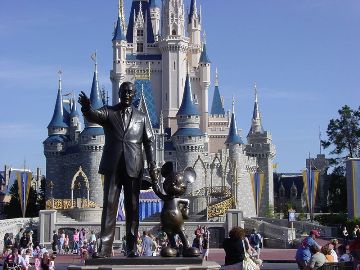
Orlando is nicknamed "The City Beautiful" and its symbol is the fountain at Lake Eola. The current mayor is Buddy Dyer. The city is best known for the Walt Disney World Resort (located approximately 21 miles (34 km) southwest of Downtown Orlando in Lake Buena Vista), founded by the Walt Disney Company in 1971, and for the Universal Orlando Resort (which consists of two parks, Universal Studios Florida and Islands of Adventure, as well as other attractions, including City Walk). Orlando is also home to the Sea World theme park, Gator land, as well as Wet 'n Wild Water Park. With the exception of Walt Disney World, most major attractions are located along International Drive. The city's famous attractions form the backbone of Orlando's tourism industry, making the city the most visited American city in 2009. The city is also one of the busiest American cities for conferences and conventions. Like other major cities in the Sun Belt, Orlando grew rapidly during the 1980s and well into the first decade of the 21st century. Orlando is also home to the University of Central Florida, which is the second largest university in the United States in terms of enrollment (as of 2011).


Orlando USA


Orlando attracts over 51 million tourists a year (3.6 million of them are international tourists). Its airport, the Orlando International Airport (MCO), is the thirteenth busiest airport in the United States, and the 29th busiest in the world.


Few people would have known about this town in Florida, if Walt Disney did not build here the ‘Disney World’ – the unparalleled amusement park
City of Orlando is located in central Florida. Tourists come here from all over the world. The city was named in honor of a soldier Orlando Reeves, who tragically died during the Liberation War.


Courtesy By: http://en.wikipedia.org/wiki/Orlando,_Florida


Saturday, April 7, 2012

US Virgin Islands


US Virgin Islands 

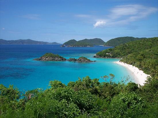
The US Virgin Islands of the United States (commonly called the United States Virgin Islands, U.S. Virgin Islands or USVI) are a group of islands in the Caribbean that are an insular area of the United States. The islands are geographically part of the Virgin Islands archipelago and are located in the Leeward Islands of the Lesser Antilles.


The US Virgin Islands consist of the main islands of Saint Croix, Saint John, and Saint Thomas, along with the much smaller but historically distinct Water Island, and many other surrounding minor islands. The total land area of the territory is 133.73 square miles (346.4 km2).


As of the 2000 census the population of US Virgin Islands was 108,612, mostly composed by those of Afro-Caribbean descent. Tourism is the primary economic activity, although there is a significant manufacturing sector.


US Virgin Islands


Formerly the Danish West Indies, they were sold to the United States by Denmark in the Treaty of the Danish West Indies of 1916. They are classified by the UN as a Non-Self-Governing Territory, and are currently an organized, unincorporated United States territory. The US Virgin Islands are organized under the Revised Organic Act of 1954, and have since held five constitutional conventions. The last and only proposed Constitution adopted by the Fifth Constitutional Convention in 2009 was rejected by the U.S. Congress in 2010, which urged the convention to reconvene to address the concerns Congress has had with the proposed document.


Courtesy By: http://en.wikipedia.org/wiki/United_States_Virgin_Islands